
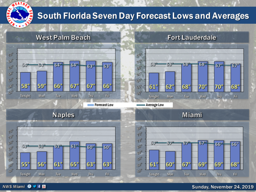
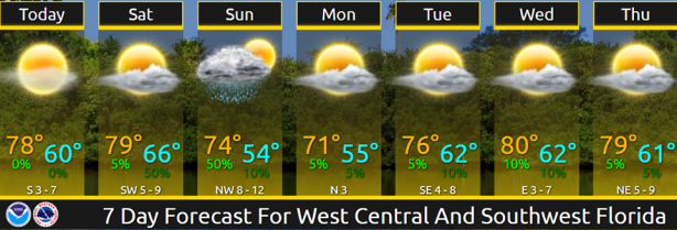
Above: forecast lows for South Florida for upcoming week will start out below average before rebounding; below: forecast highs and lows for Florida’s West Coast. (Image credits: NWS-Miami/ NWS-TampaBay)
Warm temperatures returned to the entire state Saturday, with highs in the 80s from tip to top. But the warm-up was short-lived as another cold front began rolling down the peninsula early Sunday morning.
A warming trend begins again on Tuesday, with a toasty Thanksgiving Day in the forecast, followed by what looks to be yet another cold front next weekend as December begins.
Thus, the usual winter pattern in Florida: Cold front, warm-up, rinse and repeat.
The fronts usually end up stalling in the Florida Straits and washing out, but the stronger ones make it through Cuba before running out of gas.
On Saturday, even the panhandle and North Florida made it into the 80s — Tallahassee and Jacksonville posted highs of 80 degrees, while Gainesville fell just short at 79.
Of all the principle reporting stations around Florida, Marathon in the Keys had the highest maximum with 85, but there were several warmer unofficial temperatures over mainland South Florida.
To wit: An observer just west of Zoo Miami reported a high of 88; and in Broward County, Plantation checked in with 87 and Weston was 86. An observer in western Boca Raton, Palm Beach County, reported a high of 86, as did Immokalee in inland Collier.
The state will feel the effects of the latest cold front most on Monday and Monday night into Tuesday morning, according to the National Weather Service, with Tuesday morning forecast lows of 42 in Gainesville; 44 in Tallahassee; 46 in Jacksonville; 51 in Tampa and Orlando; 66 in Miami; and 70 in Key West.
*
TROPICS WATCH: Tropical Storm Sebastien, which has stubbornly maintained its strength and classification this weekend, was forecast to begin battering the western Azores late on Sunday.
Early Sunday morning, Sebastien was racing toward the islands at 33 mph with top winds of 65 mph. It could become post-tropical before nearing the islands, but forecasters at the National Hurricane Center said: “Regardless of its status, Sebastien or its remnants are expected to bring gusty winds and rain to the Azores beginning later today.”
No other areas of interest were identified in the Atlantic by the NHC. The hurricane season officially ends next Saturday.
